Monastery of Nova Mahala
per person
The village of Nova Mahala located at 1273 m. above sea level in the Western Rhodopes. Its population is Muslim by faith, settled sometime after the late 14th c. For this reason, the toponymy in the surrounding area is Turkish, often a literal translation of previously existing local names. There is no continuity between the earlier Christian past of the area and the traditions now known. The area was included in the territory of the Roman province of Rhodope, founded by Emperor Diocletian and existing in the period ca. 293 – 640s. The province was part of the Diocese of Thrace.
The Monastery is located 3 km north-east from the village, high up in the mountain. The archaeological research was carried out in 1986 – 1989 by Katya Melamed and Andrey Mrlamed.
FORMAL ANALYSIS
The monastery complex consists of a church, monastic dormitories and a necropolis. It was studied through regular archaeological excavations in 1986-1989. The buildings are located on the eastern slope of a hill, known as Kilise burnu among the local population or Church hill/headland.
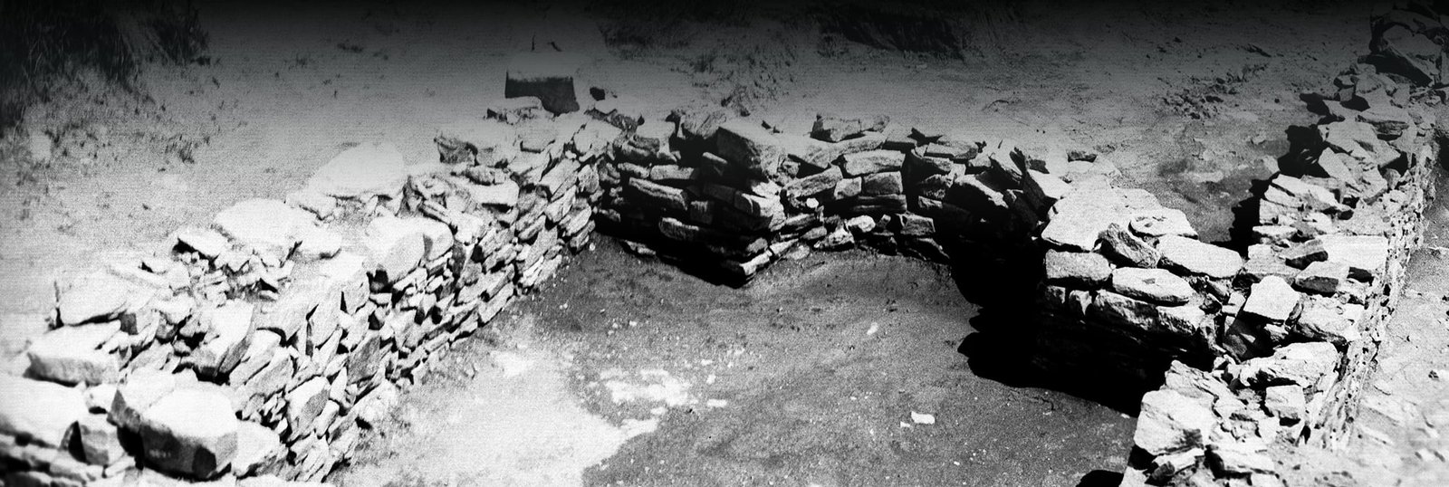
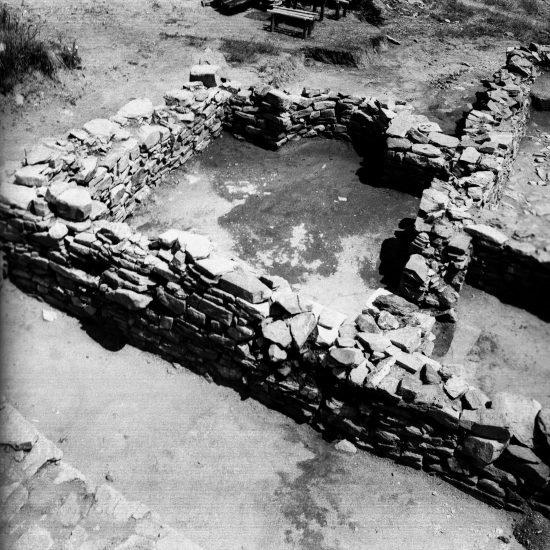
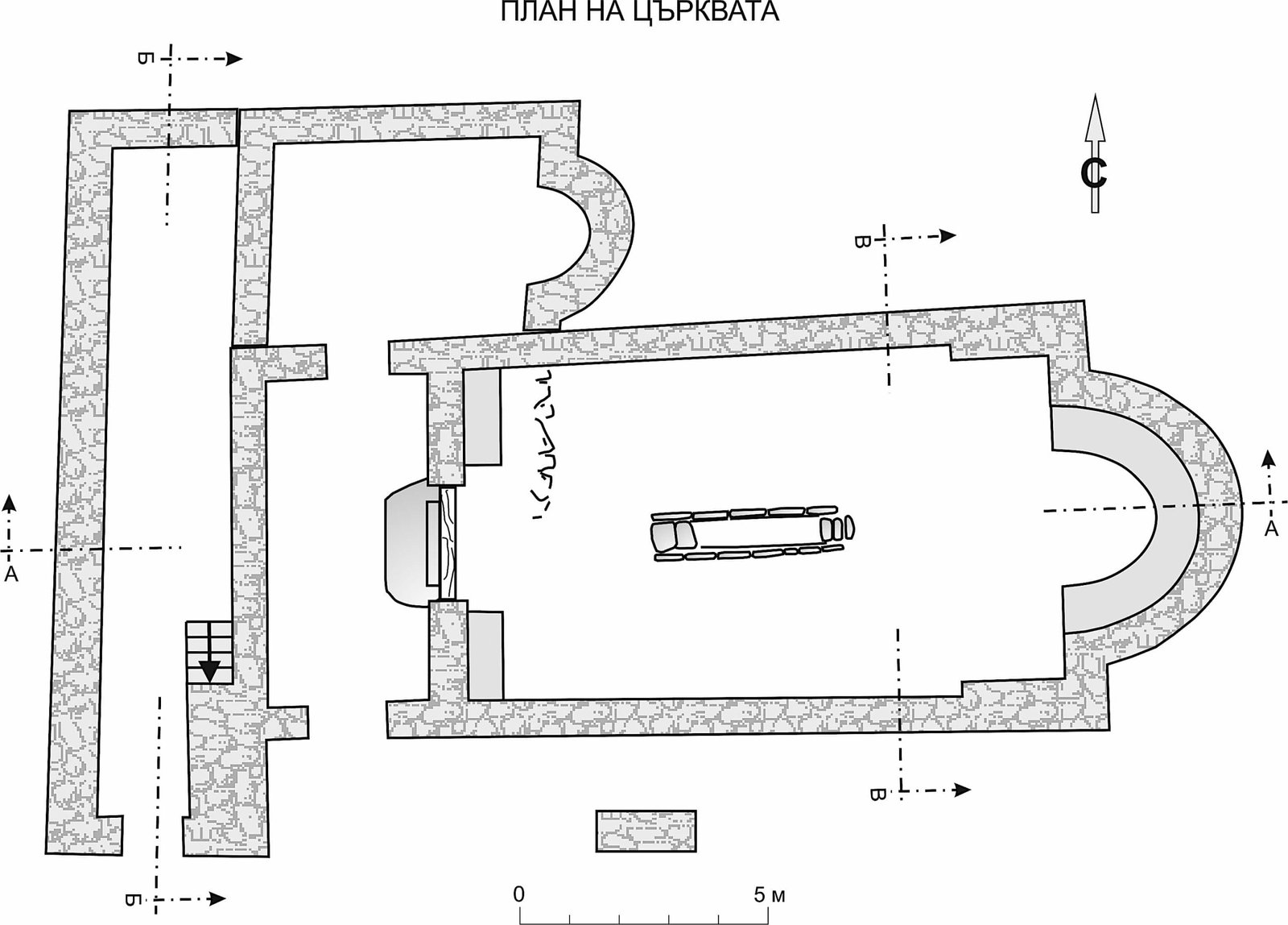
The church went through three construction periods, each of them characterized by alterations of the original plan. In the 17th century it was converted into a chapel. The plan of the first construction period is composed of a nave, an apse and a narthex with an entrance from the south. From the west the building is attached to a slope with a significant unevenness, which predetermined the position of the entrance. The nave is in the classic ratio of early churches 2:1 – 14.02 m x 7.08 m. The apse is 2.75 m wide with a depth of nearly 3 m. There are traces of a synthronon in it, of which only two of the steps have been preserved badly destroyed. The base of the altar stone is also present. In the nave a baptistery was constructed, rectangular in plan, with three steps from both east and west and a seventh step – in the middle, in the form of a small podium of two stone slabs positioned one on top of the other (dimensions 4.07 x 0.96 m; depth 0.50 m).
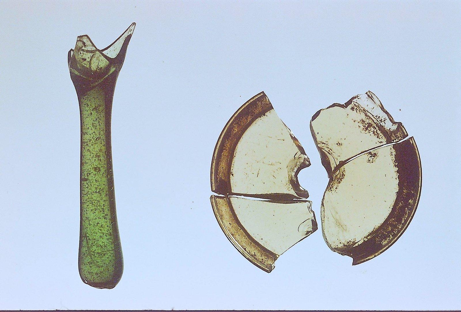
The church is built of crushed stone, fixed by yellow clay – a characteristic construction style of the local mountain Thracian population. The church had windows closed with glass. The recipe for the production of these glasses has been analyzed, but the workshop from where they were imported has not yet been localized. The floor is covered with almost square slate slabs. In front of the entrance there is a small area, also covered with slabs. It was likely covered with a canopy, judging by the pilaster hole at the end of the pavement. A channel was built under the pavement to drain groundwater from the western slope. The manner of construction and the general appearance of the church, as well as the fragmented pottery, unequivocally indicate the date of its construction – AD 4th century, as well as its local origins.
An important element in the interpretation of the events that led to the building of the church is the presence of a baptistery in the nave. This suggests a mass baptism of a local population soon after the adoption of Christianity as the official religion of the Roman Empire – as well as the question of the nature of this population. From written sources, modern historical analyzes and maps it is known that the region was inhabited by Thracians – Bessoi. Whether the Bessoi were an independent tribe or priests of the tribe of the Satrai is still a matter of debate. In any case, Paulinus of Nola’s poem in praise of the work of Nicetas of Remesiana provides some information. Among his other exploits, we also read about the conversion of the Bessoi. Eusebius Hieronymus in his sixtieth letter also mentions their conversion. So, in conclusion, the church was most likely built at the very beginning of the Christianization of the Bessoi, with a baptistery for their mass initial conversion.
According to the decisions of the IV Ecumenical Council in Chalcedon (451), the Rhodopes were included in the Metropolitanate of Traianopolis, which had 11 bishoprics, and the diocese of Rhodope was subordinate to Constantinople.
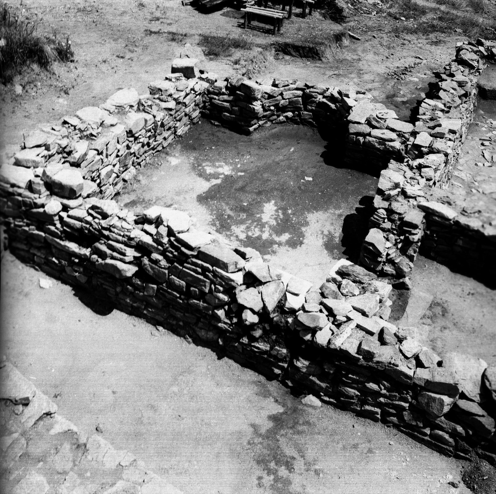
In the early 6th c., the church underwent reconstructions, is the Second construction period. The baptistery in the nave was abandoned, covered with slabs, and the nave floor was slightly raised. A small room with an apse to the east (6.85 x 4.06 m; apse 1.60 m wide, 1 m deep) was added to the northern wall of the church at a joint. The entrance to it was made through an opening in the northern wall of the church. It appears to have been built to serve as a baptistery instead of the one in the nave – three pithoi dug into the floor, one of them in the center of the apse, were found there, as well as many fragments of water vessels. Along with them, a stone box with two coins from the time of Emperor Justinian I (527-565) also appeared in the baptistery.
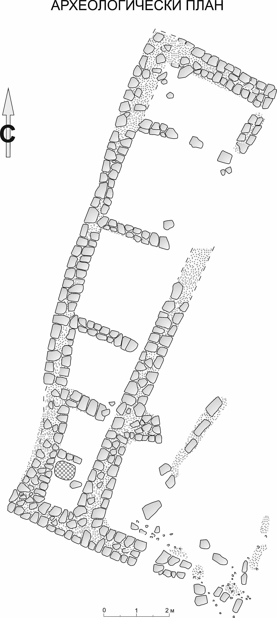
Probably at the same time or a bit earlier, a monastery was also organized around the church. To the north of it, a six-room building was constructed, oriented along its long axis north-south. All rooms are closed from the west, and from the east they open into a common corridor. Next to it, the remains of another similar building were revealed, unfortunately very badly destroyed due to agricultural activities.
Most likely, in the late 6th c., the monastery was burned down. It was a time of barbarian raids and devastation in the Byzantine Balkan dominions, which forever reshaped the administrative map of the Balkans and ushered in a new historical age.
The thoroughly studied monastery, reliably dated to the 4th – 6th centuries on the grounds of construction manners, plan organization, numerous pottery fragments and coins, is one of the earliest Christian monasteries on the territory of today’s Bulgaria.
The necropolis, located on the plateau of the hill, about 180 meters west of the monastery, is also connected with the initial period, 4th – at least until the mid 5th c. The burial rite is most likely pre-Christian, local, adopted after the conversion and practiced until the first half of the 20th c., described ethnographically and confirmed archaeologically in the territories of the Rhodopes, Southern Thrace and Eastern Macedonia. The burials were carried out in graves, fenced and covered with slate slabs. After some time, depending on the quality of the soil, the bones were removed, washed with wine and put in an ossuary – crypts of the local churches. In the grave, thoroughly cleaned up, only the sacrificial vessels remained, which in fact date well the necropolis. The grave ceased to be a place of homage. Ethnographically, the rite is known as grave leveling.
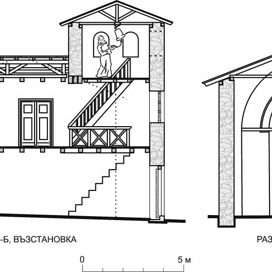
The monastery was revived again in the second half of the 10th century; is the third construction period. Changes have been made to the plan once again. The most significant change was the addition of still another room outside of the narthex western wall. Most likely, its purpose was to take the weight of the hill to which the church was abutted. At the southern end of the new room, the foundations of a staircase were revealed – most likely to a belfry. The new western room had no connection with the narthex, and hence with the nave of the church. It had an entrance from the south only. A large number of iron tools were found in it. It seems to have served as a farm store. The nave was plastered inside with white mortar and most likely decorated with paintings, judging by the traces on the walls, as well as by the fragments in blue, red and green found fallen on the church floor.
The monastery was burned again and abandoned in the 12th century. It was only in the 17th c. that the ruins of the church were rebuilt into a small chapel, but only for a short time.
KATYA MELAMED
- MONASTERY OF NOVA MAHALA © PLANS. ATANA KAMERANOV
- MONASTERY OF NOVA MAHALA (© PHOT, KATYA MELAMED: The chapel – baptistery. 6th c.
- PLAN OF THE MONASTIC CELLS © PLAN. ATANA KAMERANOV
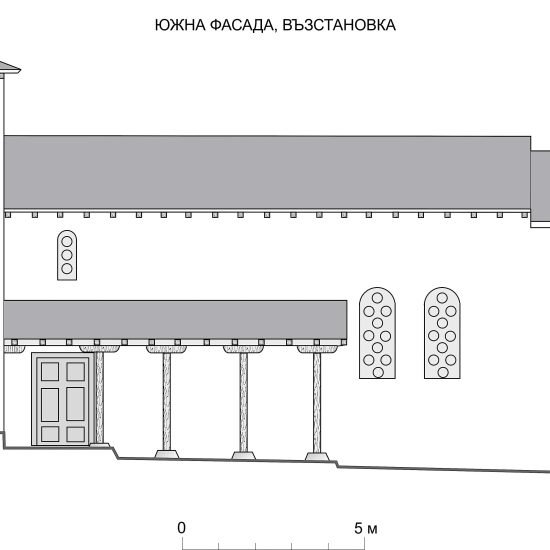
- RECONSTRUCTION OF THE SOUTHERN FACADE © PLAN. ATANA KAMERANOV
- RECONSTRUCTION OF THE WESTERN FACADE WITH THE BELFRY © PLAN. ATANA KAMERANOV
- FRAGMENT OF GLASS LUCERNAE FOUND IN THE CHURCH © PHOT. KATYA MELAMED
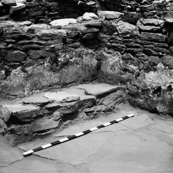
- WESTERN WALL BENCH WITH TRACE OF WALL PINTINGS BEHIND 10TH C. © PHOT. KATYA MELAMED
Tour Location
Monastery of Nova Mahala
| Other monuments and places to visit | None in the area |
| Natural Heritage | |
| Historical Recreations | |
| Festivals of Tourist Interest | |
| Fairs | |
| Tourist Office | In Batak and Pazardzhik |
| Specialized Guides | |
| Guided visits | |
| Accommodations | In the nearby Batak or better in Pazardzhik |
| Restaurants | In the nearby Batak or in Pazardzhik |
| Craft | |
| Bibliography | |
| Videos | |
| Website | info@visitbatak.bg;visit pazardzhik |
| Monument or place to visit | Unfortunately the Monastery is high up in the mountains reaching along a steep dirty road. No conservation works have been performed. The artefacts found are on display in Batak Historical Museum and Regional Historical Museum in Pazardzhik. |
| Style | Remains of Late Antiquity mountain local Thracian architecture |
| Type | Monastic architecture |
| Epoch | 4th – 6th – 10th centuries |
| State of conservation | No conservation has been carried out |
| Mailing address | museum_batak@abv.bg museumbatak.com Instagram:museum_batak museumpz@abv.bg |
| Coordinates GPS | Latitude 41.94281389 Longitude 24.28699722 |
| Property, dependency | Monument of culture of national significance; Ministry of Culture – Republic of Bulgaria |
| Possibility of visits by the general public or only specialists | Yes, open to public, no entry needed |
| Conservation needs | Extremely necessary |
| Visiting hours and conditions | In general 9 a.m. – 5 p.m.; more details on museumpz@abv.bg; Batak: June – August 9 a.m.-6.30 p.m.; September – May 9 a.m.-5 p.m. |
| Ticket amount | Pazardzhik - 3 BGN; discounts depending on the number of visitors, age, etc.; Batak – adults 4 BGN; pupils, students and pensioners 2 BGN |
| Research work in progress | |
| Accessibility | Difficult |
| Signaling if it is registered on the route | |
| Bibliography | Меламед, А. Култов комплекс в землището на с. Нова махала. – Rhodopica 1999/ 1, 83-90; a summary in English: Melamed, A. A Cult Complex at the settlement of the village of Nova Mahala. Меламед, К. Светилище и некропол до раннохристиянския манастир край с. Нова махала, Баташко. – Археология 1993/ 2, 36-46; a summary in French: Sanctuaire et nécropole du monastère de la haute époque chrétienne prés du village de Nova Mahala, district de Batak. Melamed, K. Early Christian Church in Bansko: Local Traditions Following the Byzantine General Religious Programme. – In: Proceedings of the 22nd International Congress of Byzantine Studies. Sofia 22 – 27 August 2011. Volume III, p. 97. Soustal, P. Tabula Imperii Byzantini. Band 6: Thrakien. Vienna 1991, S. 377. Detcheva, A. K., J¨urgen Hassler. INVESTIGATION OF LATE-ANTIQUE AND EARLY-CHRISTIAN GLASS ARTEFACTS FROM SOUTH-WEST BULGARIA BY MEANS OF ELECTROTHERMAL VAPORIZATION INDUCTIVELY COUPLED PLASMA OPTICAL EMISSION SPECTROMETRY. - In: Comptes rendus de l’Acad´emie bulgare des Sciences Tome 71, No 4, 2018 CHEMISTRY Analytical chemistry. |
| Videos | |
| Information websites | |
| Location | The Monastery is located 3 km north-east from the village of Nova Mahala |
